With this AR App I would like to generate a discussion about how bad is the condition of the bike roads and in general biker’s life in NYC.

When we bikers are calm.
When we are pissed off!

Alternative solutions.
:no_upscale()/cdn.vox-cdn.com/uploads/chorus_asset/file/2340178/R67Iwnau9AI.0.jpg)


Graphic ideas for weight points:

Question on the fly:
How to localize without GPS?
A great solution would be RSSI Fingerprinting which is basically creating a gird of nodes which has signal strength and mac address. Unfortunately it only works on Android.
How it should work in the future:
I would like to create a similar app which allows bikers to make a photo of the hazard on the road/ the car who is parking on the bike road. The picture will stay in the location where they were photographed. By time it can be not only a nice tool for reports of road conditions but can be also a time-based ar installation which would draw attention to the fact that biking NYC is dangerous.
How this works now:
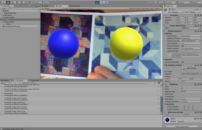
For now I was experimenting with the Placenote SDK which allows to capture a map which is lets you scan any space and turn it into a smart canvas for positioning AR objects. Placenote integrates with ARKit on iOS devices by wrapping ARKit’s tracking functionality in a cloud-based computer vision and machine learning API that lets you build Persistent AR apps quickly and easily.
Augmented Reality SDK with computer vision to save map information so that we can re-localize it later.
ArCore >> Using cloud anchors which can be recognized by iOS. It only stores them for 24hours. The trick is Placenote!
Placenote SDK ( takes care of cloud storage for us ) only works for iOS. It lets you quickly build cloud-based AR apps that permanently save AR content in physical locations, indoors and outdoors. https://placenote.com/
Placenote only saves MAPS. The content has to be save locally or on the back end a private server.
We can DROP WEIGTH POINTS as we move through the indoor space.


Problems:


Future ideas:
Use it outside with a different SDK with GPS.
Print out image target which can be sprayed on the corner.